Showing posts with label Wyoming. Show all posts

Sunday, July 15, 2018

1937 Vintage Road Trip Scrapbook - Part 23 - Crossing Wyoming through the Big Horns

(for part 1, click here)

Crossing Wyoming

The Johnsons are now in the home stretch, but there's still plenty of adventure left! According to the map at the beginning of the scrapbook, they left Yellowstone via Hwy 20 (which I believe is now the equivalent of Hwy 14) traveled through Cody to Greybull, then south to Worland.

There's a pamphlet for Thermopolis, WY in the scrapbook (see bottom picture) so they may have taken the 33 mile stretch south to visit, though it's not marked on their main map. Either way, they eventually took Hwy 16 east and north through the Bighorn Mountains.


I've driven over the Bighorns a couple of times, and if it's your first time driving in Mountains, it can be a bit of a white-knuckled ride, especially back in 1937 when the roads weren't as nice as they are now. But it is a beautiful and breathtaking drive, so if yo have time, take that route instead of the faster, but not as awe-inspiring Interstate 90.

Below is the above Big Horns pamphlet opened up;


Close-up of the other little map on the above page;


The black and white postcard on the scrapbook page below is captioned, "Hair Pin Turn - Ten Sleep Canyon on U.S. Highway 16, near Buffalo, Wyoming."


I wonder how the Johnson's LaSalle did travelling up and down the Big Horns and navigating the sharp turns and switchbacks. Did Joan and family ever have a flat tire? Run out of gas? Did anyone get sick on their journey? It's impossible to know all of the details, of course, but it's fun to imagine.

Anyway, after coming out of the Big Horns, our adventurous family drove through Buffalo, and then perhaps going to the Sheridan Rodeo advertised below. It was a bit out of the way of their drawn route, but not too far.

I love the vibrant colors of this old ad.


Also, today, as I write this, it is July 15th, 2018 - exactly 81 years (give or take a day depending on which of these three days they attended) ago.

Whether or not they trekked up to Sheridan, they would have soon drive through Ucross, picking up Hwy 14, which took them north, east, and back south to Gillette, then east again past Devil's Tower. Hwy 14 soon took them into South Dakota, via Spearfish.

Nameless Cave (6-1/2 miles west of Rapid City!) is in the Black Hills, but is now privately owned, and no longer open to the public, dagnabbit! Luckily, if you go to the Black Hills today, there are many other great caves to tour.


The Thermopolis pamphlet as well as a National Service Bureau brochure showing points of interest in the Black Hills. It has a map on the back, as well as noting service stations located within the hills.


Next, the Johnsons spend more time in South Dakota. We will also see some more of Joan's artwork!


Saturday, July 14, 2018

1937 Vintage Road Trip Scrapbook - Part 21 - Yellowstone, Part 2


More Yellowstone

I don't know where the Johnsons stayed in Yellowstone. Maybe they drove on through in single day (which would be a shame.) They may have camped or stayed in one of the lodges or inns. Hard to tell from the scrapbook. 


Below are close-up of the postcards from the above page. I like how it looks like there's a face within the billowing steam of Old Faithful. Below the following postcard, our intrepid reporter Joan writes, "150 ft high. This is the most celebrated picture ever taken of this famous geyser, which with clock-like regularity gives its exhibitions at intervals of 60 to 80 minutes..." I believe there's another line written under this, but it's too faded to read.


Below is a postcard of Giant Geyser, of which Joan writes, "This geyser continues each display for an hour and a half. Its intervals of quiet between eruptions vary from six to fourteen days."


Below is a postcard of the Old Faithful Inn, which was constructed in 1904. I love this old building, and spent many evenings inside, writing, reading, and listening to the piano player while having a few cocktails. If you want to see a couple blog posts of pics I took inside the Inn, you can find them here   and  here.


Among the scrapbook pages of Yellowstone, Joan showed some of her drawing skills with pics of flowers. Below is a yellow waterlilly.


Below is a Cedar Juniperus Scopulorum (aka Rocky Mountain Juniper)


Last but not least is Joan's drawing of a giant daisy.


Believe it or not, there are a few more pages that Joan dedicated to their time in Yellowstone.


Saturday, June 28, 2014

Medicine Wheel - Bighorn Mountains, Wyoming - 2014 Author Tour - Part 9

(To start at the beginning of this series of posts about my 2014 Author Tour, go here)

I wanted to see the Medicine Wheel located off highway 14A near the northern border of Wyoming in the Bighorn Mountains. To get there, you exit the highway (it's well marked) and drive a mile and a half up a narrow dirt road, park, and then hike another mile and a half to the site. It's at a high altitude - close to 10,000 feet above sea level - and I'm not in the best shape, so I had to stop and rest often along the trail. Also - even though it was late June - parts of the trail were blocked with snow. It was a little scary walking through this slippery part, with about a forty foot drop (though not steep) to the side:


There was one particularly large snow drift that I had to walk around. On the way out, I circled above it - the way I'd recommend - and on the way back, I circled below it, slipped and fell on my butt in a bunch of mud - not recommended! Bu most of the way was clear and wide:


Along the way I met this little fella:


The Medicine Wheel is atop that rise on Medicine Mountain:


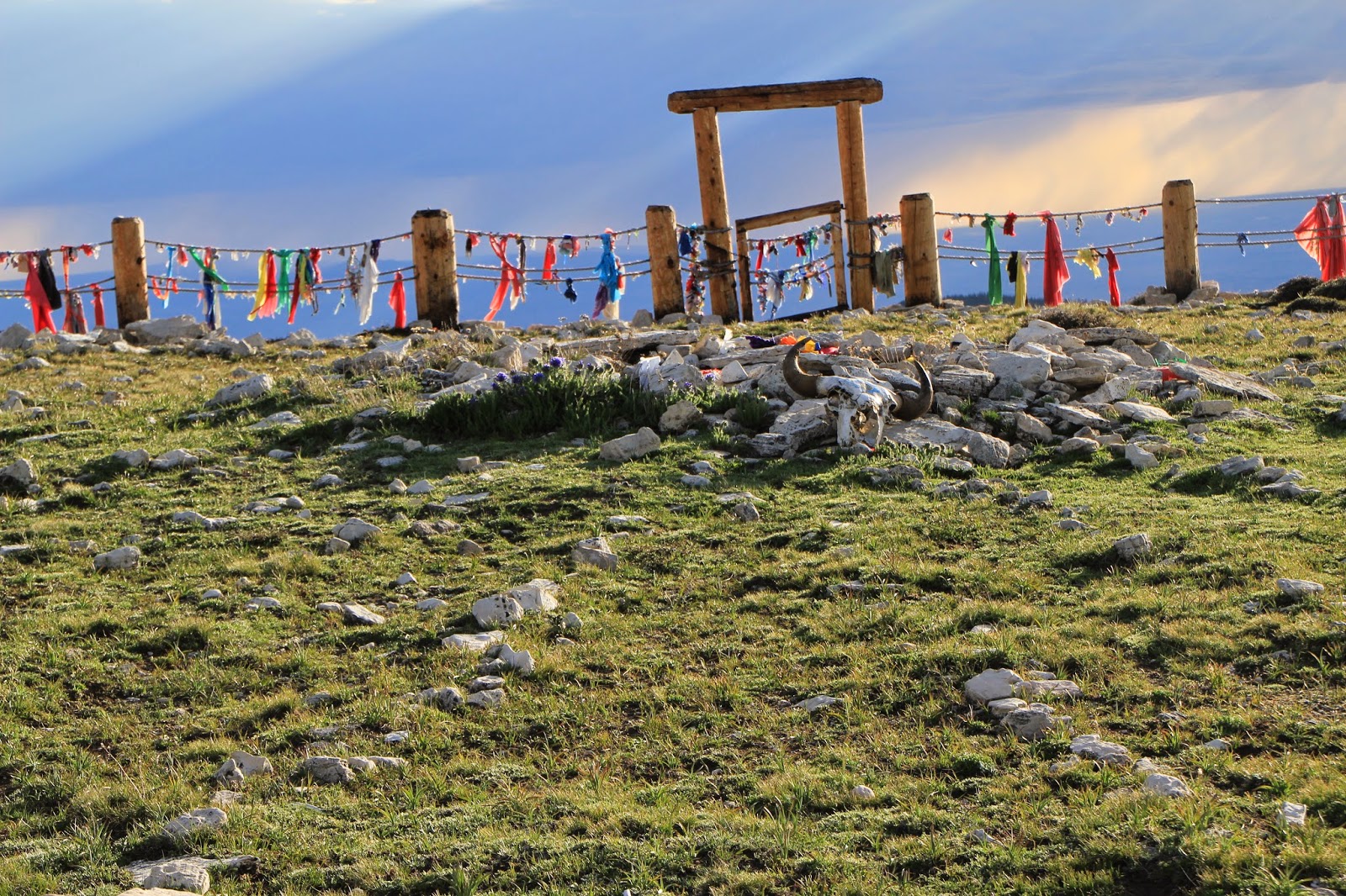
The Medicine Wheel is sacred to many Native Americans. It's estimated to be anywhere from 300 to 800 years old. It's about 80 feet in diameter, with 28 spokes radiating from the central cairn. There are six smaller cairns along the outer circle. There's a fence around the whole thing, and you need special permission to enter into the wheel. Here's the central cairn. Notice the buffalo skull. Those colorful ribbons on the fence are offerings or tokens of thanks. People also leave bunches of sage, hoops, shells, rocks; all kinds of different symbols of appreciation for their ancestors or spirits.


Tokens of prayer and appreciation:


Shell left on a post:

I found a cool looking rock on the trail that looked a little like a paw, and left it on the post. I closed my eyes and asked to know my ancestors better - the next moment, there was a strong gust of wind, as if in answer.

Some more pictures of the Medicine Wheel (considered a sacred hoop by some):


For some of the astronomical significance of the alignment of the spokes, there's some good information here.

I recommend checking this out. Just know that the trail is only clear for a few months in the summer, and that it's at a high altitude. The scenery from everywhere along the trail is beautiful. Be respectful of the place, and stay on the trail!

Here's a cool view I saw walking back to my car - the sun peeking through clouds, illuminating a spot on the distant mountains:


Thanks for stopping by!